


Aerial view of a desert kite from Jebel az-Zilliyat, Saudi Arabia
O. Barge, CNRS
The oldest documented building designs to scale date back to around 9000 years ago, and they depict massive stone-walled hunting traps.
The plans for these sophisticated traps, known as desert kites, were inscribed into large stone tablets, which were just recently unearthed in the area. These traps span such great distances that their shapes are only discernible from the sky. Rémy Crassard, a researcher at the French National Centre for Scientific Research (CNRS), believes the findings prove that Neolithic people had a “underestimated mental mastery” of landscapes and space even before they developed literacy.
“There is no doubt that these Homo sapiens had the same degree of intelligence that we do,” he adds. “But this is the first time we actually have concrete proof of their spatial perception — in both these gigantic kites and now also in their very precise corresponding plans.” “It demonstrates how deeply ingrained this way of thinking was in their society.”
In Saudi Arabia and Jordan, kites can have funnelling lines as long as 5 kilometres and as many as 10 pointed branches that descend into trenches as deep as 4 metres. According to Wael Abu-Azizeh of the French Institute of the Near East, the structures were likely used to lure gazelles or other wild prey into the narrower parts of the structure, where they would be cornered or fall, earning them their name from the aeroplane pilots who first discovered them from the air in the 1920s and thought they looked like toy kites.

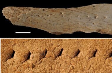
A stone at Jibal al-Khashabiyeh, Jordan, engraved with a plan of a desert kite
SEBAP & Crassard et al. 2023 PLOS ONE
However, the few artistic depictions of these Stone Age structures have only been found to be rough abstract sketches, despite their complexity. Some 2300 years ago, in the time of the Mesopotamians, scientists thought they had discovered the earliest authentic architectural blueprints that were at least supposed to be to scale.
Crassard and his team discovered an 80-centimeter long, 92-kilogram limestone tablet with intricate building blueprints engraved upon it in an excavated campground in Jordan near a 9000-year-old kite in March 2015. Even more unbelievable was the discovery of a second kite plan just three months later, engraved into a 3.8-meter-tall sandstone boulder that had fallen from a cliff near a pair of 7500-year-old kites in Saudi Arabia.
“These were really emotional moments for us in our scientific careers,” Crassard recalls. Finding even one was a rare occurrence, so discovering two was beyond miraculous. We were screaming and having a good time.
Researchers found mathematical connections between the etched images and satellite photographs of 69 kites thanks to the application of computer modelling. Within one to two km, they found that the stone carvings were “surprisingly realistic and accurate” depictions of genuine kites, as claimed by Crassard. Both drawings were drawn to scale (1:175) and included pitting in three dimensions to depict the kites’ pit traps (1:425).
Abu-Azizeh speculates that the blueprints not only assisted in the construction of the massive, intricate structures, but also helped hunters understand how to make the most of them.
Sam Smith from Oxford Brookes University in the UK, who was not involved in the study, argues that this is the most likely explanation. Members of the Neolithic community may have used the scale representations as a means of communicating group hunting plans, similar to how football managers might use a white board to write out their strategy for the team. He explains, “It’s not hard to picture how these engravings would have been an essential part of planning.”
Moreover, he speculates that their engraving in “such a durable medium” was done with posterity in mind. Smith argues that without images like this, newcomers to the community or hunting party would have no way to understand the kites.
It’s puzzling, adds Olivier Barge, another CNRS researcher, that ancient engineers managed to achieve such geometric precision without sophisticated equipment like a GPS or tacheometer. As they say, “We don’t know how they did it.”
1. What are desert kites?
Desert kites are intricate stone-walled hunting traps designed by Neolithic people around 9000 years ago in Saudi Arabia and Jordan. These traps were used to capture wild prey like gazelles.
2. How were the ancient kites discovered?
Researchers, led by Rémy Crassard of the French National Centre for Scientific Research (CNRS), unearthed large stone tablets with engraved plans of desert kites in Saudi Arabia and Jordan. The plans were discovered in recent years and shed light on the advanced architectural skills of the Neolithic era.
3. What do the desert kite plans reveal about Neolithic people’s intelligence?
The plans indicate that Neolithic people possessed advanced spatial understanding and mental mastery of landscapes even before the development of literacy. The sophisticated designs of the kites and their accurate scale representations showcase their intelligence.
4. How were the desert kites used for hunting?
The kites featured funneling lines as long as 5 kilometers and pointed branches leading to deep trenches. These structures likely lured wild prey into the narrower parts, where they would be cornered or fall, aiding in successful hunting.
5. What was the purpose of engraving the kite plans on stone tablets?
It’s believed that the engraved plans not only aided in constructing these complex structures but also helped hunters understand how to effectively utilize the traps. The plans could have served as a means of communicating hunting strategies within the Neolithic community.
6. What technology did ancient engineers use for such precise designs?
Despite the absence of advanced tools like GPS or tacheometers, ancient engineers achieved impressive geometric precision in their designs. The exact methods they used remain a mystery to modern researchers.
7. How were the kite plans related to the Mesopotamians’ architectural blueprints?
Unlike the abstract sketches found in Mesopotamian times, the Neolithic kite plans were intricate and accurate scale representations. These plans showcase the early existence of detailed architectural blueprints.
8. Were there any emotional moments during the discovery?
Yes, Rémy Crassard and his team were amazed by the discovery of two kite plans in such a short span. Finding these plans was a rare and miraculous occurrence for the researchers.
9. What role did the engraved plans play in the Neolithic community?
The plans might have been used for communicating hunting strategies and sharing knowledge within the Neolithic community. They served as a valuable tool for understanding the construction and usage of the kites.
10. What insights do the kite plans offer about ancient society?
The engraved plans provide concrete evidence of the Neolithic people’s spatial perception and their deep understanding of landscapes. This showcases the significance of spatial awareness in their society.